
Coastal Engineering: People, Places & Practices
Grade/Topic/Subjects
For: Grade 6 – 8
Topic: Coastal engineering
Subject areas: Art | Environmental Literacy | Language Arts | Mathematics | Science & Engineering | Social Studies
Curriculum Summary
This curriculum project was originally designed to connect middle school students and staff from Jerstad-Agerholm School in Racine, Wisconsin, to their Lake Michigan watershed by exploring coastal engineering concepts through meaningful watershed educational experiences.
Additionally, it was important for us to include career pathways that introduce students to a variety of coastal engineering, green infrastructure, and healthy beach management careers—hence the people portion of the project.
The curriculum topics are broadly applicable to other locations within the Great Lakes basin.
The lessons were written by Wisconsin Sea Grant (WiSG) coastal engineer Adam Bechle and education staff Virginia “Ginny” Carlton and Anne Moser. The lessons were reviewed by WiSG editor Elizabeth White and designed by Ginny using concepts originally created by WiSG graphic designer Sarah Congdon.
The supporting videos and website were produced by WiSG communication staff Bonnie Willison and Tom Xiong.
This curriculum was prepared under award number NA21NOS4290005 from the Great Lakes Bay Watershed Education and Training (B-WET) program of the National Oceanic and Atmospheric Administration (NOAA), U.S. Department of Commerce. The statements, findings, conclusions and recommendations are those of the author(s) and do not necessarily reflect the views of NOAA or the U.S. Department of Commerce.
The link below will download a Microsoft Word document. Note that Microsoft Word may not consistently hold formatting. The authors chose to provide Word documents rather than Adobe pdf files so the content can be easily updated for your geographic location.
LESSON SUMMARY
Middle school students are introduced to the field of coastal engineering and start to become familiar with the engineering design process, a key method coastal engineers use to address problems at our shorelines. Current coastal engineering issues include erosion, loss of habitat, flooding, property damage, threats to human life and wellbeing, and more. The students are also oriented to the location of the field site on the shore of Lake Michigan at North Beach. The geographic positions of the school, Lake Michigan, and Racine Harbor serve as reference points as students build, or enhance, their personal conceptual geographic map of natural and constructed features within the city of Racine.
LEARNING OBJECTIVES
Students can
- Identify the steps of the engineering design process.
- Explain the similarities and differences between science and engineering.
- Perform tasks foundational to creating a map (e.g., estimate the distance between specified locations and determine the spatial orientation between two locations) by completing a distance and relative position chart.
- Draw a map illustrating the relative positions of the school, Lake Michigan, and a feature of the student’s choice.
- Iteratively use the engineering design process to create a sequence of clay objects with the goal of designing an object that floats.
LINK TO FULL LESSON PLAN AND DETAILED OVERVIEW
The link below will open a webpage that provides a more detailed overview of this lesson including information about academic standards, Great Lakes literacy principles, and hyperlinks to the full lesson plan and all supporting files.
Lesson 1: Introduction to Coastal Engineering – Learn More
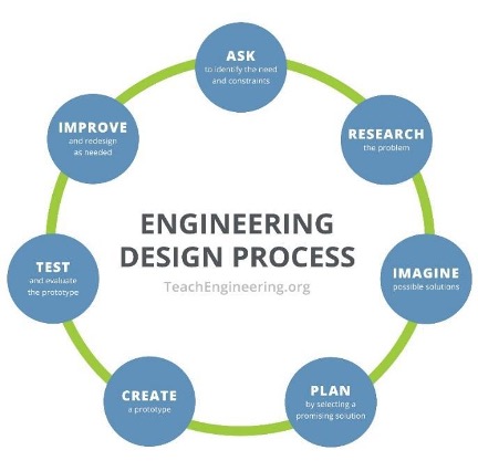
Image source: TeachEngineering
LESSON SUMMARY
Learning the basics of coastal engineering and the features of the Great Lakes enables students to understand what they see at the North Beach field site. In the 19th and 20th centuries, the transformation of the Lake Michigan shoreline resulted in deeper harbors and safer transportation infrastructure, including changes at the Racine Harbor. Human activity, coordinated by coastal engineering practices, has helped create the North Beach we see today. By understanding this change in coastal configuration, the students are introduced to the intended and unintended consequences of engineering. In this lesson, students are exposed to a variety of coastal features found around the Great Lakes and those specific to North Beach. In addition, they are exposed to the coastal processes (one of which is changing water levels) that continue to shape these features.
It’s important for the students to understand that scientific investigations often answer questions such as how one thing is related to another. For example, it is important for students to understand that water levels change not only from year to year but also from season to season. Additionally, water doesn’t only increase and decrease in depth, it also moves from one location to another. This lesson will highlight some of the ways water moves and the forces that cause it to move.
LEARNING OBJECTIVES
Students can
- Label a coastal diagram when given a set of terms — thereby demonstrating an understanding of common terms used to describe coastal ecosystems.
- Describe components of the water budget/water cycle that influence lake levels.
- Analyze a graph to determine the highest and lowest water levels (to the nearest foot IGLD 1985) ever recorded between 1920 and 2021 for Lake Michigan. Then use these numbers to calculate the magnitude of the change in water level.
- Explain the four processes (changes in lake level due to water cycle, water movement via waves, water movement via currents, and sediment transport) that shape the coast.
- Describe what happens to a beach that is exposed to the force of waves or currents.
LINK TO FULL LESSON PLAN AND DETAILED OVERVIEW
The link below will open a webpage that provides a more detailed overview of this lesson including information about academic standards, Great Lakes literacy principles, and hyperlinks to the full lesson plan and all supporting files.
Lesson 2: The Coastal Features and Processes of the Great Lakes – Learn More
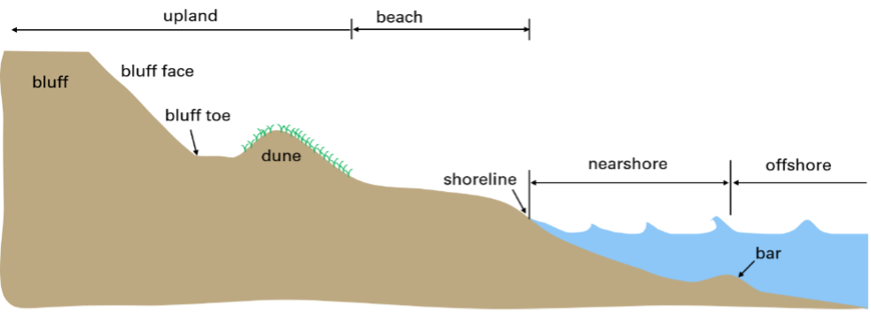
Image source: Adam Bechle, Wisconsin Sea Grant
LESSON SUMMARY
Students are introduced to seven common solutions coastal engineers use to protect the shoreline from flooding, erosion, poor water quality and beach closures. These common engineered solutions include structures such as revetments and breakwaters and practices such as beach nourishment or green infrastructure. Lesson three specifically focuses on the engineering structures built at North Beach: revetment, breakwater, jetty and seawall. In addition, the students expand their spatial learning with the introduction of Google Earth as a mapping tool.
LEARNING OBJECTIVES
Students can
- Name at least three design considerations engineers must take into account when planning to install a coastal engineering structure that is designed to reduce or mitigate a natural coastal hazard.
- Generalize the benefits (e.g., flood control, erosion management, and beach stabilization) and challenges (e.g., changes to sediment transport processes that can have impacts to neighboring properties, cost, working in water of varying depths, available space) of designing and installing coastal engineering structures.
- Complete a Google Earth project that maps specified natural and man-made features associated with the area containing the city of Racine and North Beach.
LINK TO FULL LESSON PLAN AND DETAILED OVERVIEW
The link below will open a webpage that provides a more detailed overview of this lesson including information about academic standards, Great Lakes literacy principles, and hyperlinks to the full lesson plan and all supporting files.
Lesson 3: Coastal Engineering Structures – Protecting the Shoreline
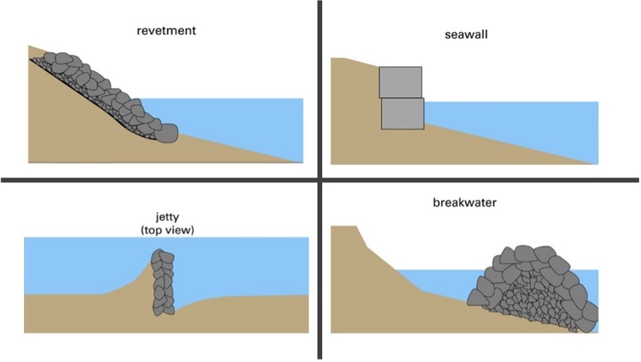
Image source: Adam Bechle, Wisconsin Sea Grant
LESSON SUMMARY
Students are reintroduced to the hydrologic cycle — the natural path water takes due to gravitational forces, beginning with precipitation, then infiltration or runoff, and finally via flow through rivers and wetlands as the water travels to Lake Michigan. Students are introduced to ways in which humans have altered the natural path of water flow (e.g., via installation of impermeable surfaces). Finally, students are exposed to the consequences of this interference by considering the impacts of stormwater management.
Because coastal waters are connected to surface water and groundwater via the hydrologic (water) cycle, students need to understand how engineers manage water movement within the entire watershed in addition to understanding how engineers use coastal structures to manage the movement of water and sediments along the coast.
LEARNING OBJECTIVES
Students can
- Identify at least two human actions or infrastructure elements that influence how water moves across the landscape.
- Generalize the natural path of water movement beginning with precipitation falling within the city of Racine and ending with water entering Lake Michigan.
- Generalize the path of water movement through storm water management infrastructure that is designed to move water from where it falls within the city of Racine to where it enters Lake Michigan.
- Make predictions related to how water will percolate through soil, and document whether their observations support their predictions.
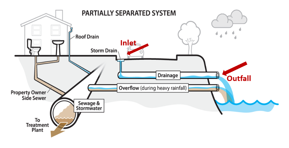
Image source: City of Seattle
LINK TO FULL LESSON PLAN AND DETAILED OVERVIEW
The link below will open a webpage that provides a more detailed overview of this lesson including information about academic standards, Great Lakes literacy principles, and hyperlinks to the full lesson plan and all supporting files.
LESSON SUMMARY
Students begin to synthesize the previous four lessons. They consider the amount of rain recorded in the city of Racine, calculate the amount of that rain that runs off roofs, and learn about natural and manmade structures, especially green infrastructure, that manage that runoff.
LEARNING OBJECTIVES
Students can
- Perform calculations related to the amount of water collected from a roof.
- Describe the importance of wetlands.
- Describe a green infrastructure project design including the component of the water cycle (infiltration, transpiration, evaporation) it is designed to alter.
- Perform calculations to determine the size needed for a rain garden, one example of green infrastructure.
LINK TO FULL LESSON PLAN AND DETAILED OVERVIEW
The link below will open a webpage that provides a more detailed overview of this lesson including information about academic standards, Great Lakes literacy principles, and hyperlinks to the full lesson plan and all supporting files.
Lesson 5: Introduction to Green Infrastructure
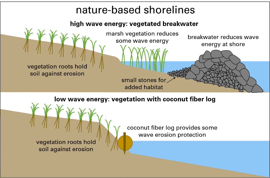
Image source: Adam Bechle, Wisconsin Sea Grant
LESSON SUMMARY
Students prepare for their field trip by exploring the coastal engineering approaches found at North Beach where coastal engineers have used both gray infrastructure and green infrastructure to protect the coast. The students recall the coastal processes and features that influence the shoreline’s shape and how coastal engineers have used infrastructure approaches to control flooding, mitigate erosion and improve water quality at North Beach, Racine, Wisconsin.
LEARNING OBJECTIVES
Students can
- Perform calculations related to the amount of water generated from parking lot runoff and the size of a rain garden needed to manage this water.
- Differentiate gray infrastructure from green infrastructure.
- Describe a green infrastructure project at North Beach that manages water quality, quantity, or water movement, specifying what problem the project addresses and the design considerations.
LINK TO FULL LESSON PLAN AND DETAILED OVERVIEW
The link below will open a webpage that provides a more detailed overview of this lesson including information about academic standards, Great Lakes literacy principles, and hyperlinks to the full lesson plan and all supporting files.
Lesson 6: Coastal Engineering at North Beach – Learn More
Image source: Adam Bechle, Wisconsin Sea Grant
Supporting Videos About the Project
Coastal Engineering Education in Racine: Ms. Taneka Golden – Seventh grade teacher, Jerstad-Agerholm School in Racine, Wisconsin
Coastal Engineering Education in Racine: Adam Bechle – coastal engineer, Wisconsin Sea Grant
Coastal Engineering Education in Racine: Ginny Carlton – education outreach specialist, Wisconsin Sea Grant
Coastal Engineering Education in Racine: Anne Moser – librarian and education coordinator, Wisconsin Sea Grant
Coastal Engineering Education in Racine: Lydia Salus – program coordinator, Wisconsin Coastal Management Program