
Lesson 2 – The Coastal Features and Processes of the Great Lakes
LESSON SUMMARY
Learning the basics of coastal engineering and the features of the Great Lakes enables students to understand what they see at the North Beach field site. In the 19th and 20th centuries, the transformation of the Lake Michigan shoreline resulted in deeper harbors and safer transportation infrastructure, including changes at the Racine Harbor. Human activity, coordinated by coastal engineering practices, has helped create the North Beach we see today. By understanding this change in coastal configuration, the students are introduced to the intended and unintended consequences of engineering. In this lesson, students are exposed to a variety of coastal features found around the Great Lakes and those specific to North Beach. In addition, they are exposed to the coastal processes (one of which is changing water levels) that continue to shape these features.
It’s important for the students to understand that scientific investigations often answer questions such as how one thing is related to another. For example, it is important for students to understand that water levels change not only from year to year but also from season to season. Additionally, water doesn’t only increase and decrease in depth, it also moves from one location to another. This lesson will highlight some of the ways water moves and the forces that cause it to move.
LESSON CONCEPTS
- Water’s movements — both on the land and underground — cause weathering and erosion, which change the land’s surface features.
- The abundance of liquid water on Earth’s surface and its unique combination of physical and chemical properties are central to the planet’s dynamics.
- A variety of hazards result from natural processes.
- Humans cannot eliminate natural hazards but can take steps to reduce their impacts.
- Human activities can contribute to the frequency and intensity of some natural hazards.
- The sustainability of human societies and the biodiversity that supports them require responsible management of natural resources. Scientists and engineers can make major contributions — for example, by developing technologies that produce less pollution and waste and that preclude ecosystem degradation.
LEARNING OBJECTIVES
Students can
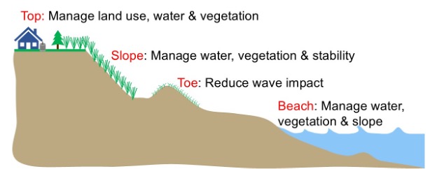
- Label a coastal diagram when given a set of terms — thereby demonstrating an understanding of common terms used to describe coastal ecosystems.
- Describe components of the water budget/water cycle that influence lake levels.
- Analyze a graph to determine the highest and lowest water levels (to the nearest foot IGLD 1985) ever recorded between 1920 and 2021 for Lake Michigan. Then use these numbers to calculate the magnitude of the change in water level.
- Explain the four processes (changes in lake level due to water cycle, water movement via waves, water movement via currents, and sediment transport) that shape the coast.
- Describe what happens to a beach that is exposed to the force of waves or currents.
The link below will download a zipped file containing Microsoft Word documents and Microsoft PowerPoint files. Note that Microsoft Word may not consistently hold formatting. The authors chose to provide Word documents rather than Adobe pdf files so the content can be easily updated for your geographic location.
- Detailed Version of Lesson 2 — The Coastal Features and Processes of the Great Lakes
- Educator Background Information The Coastal Features and Processes of the Great Lakes – Background
- Background Slideshow Coastal Processes Demonstration — The Wave Tank
- PowerPoint for Assessment Lake Michigan Water Levels
- Student Handout Lake Michigan Water Levels
- Assessment Answer Key Lake Michigan Water Levels Answer Key
- Educator Background Slideshow Coastal Processes Demonstration —
The Wave Tank - Student Handout Water and Sediment on the Lake Michigan Shoreline
- Assessment Coastal Terms Drag and Drop
- Assessment Answer Key Coastal Terms Answer Key
- Slideshow Four Coastal Processes
- Student Handout Historic Beach Width Measurement
The link below will open a Google form.
BUILD YOUR OWN UNIT PLAN
| ACTIVITY | TIME NEEDED | |
| Lesson 2: Lake Michigan Water Levels | 10 minutes | |
| Lesson 2: Water and Sediment on the Lake Michigan Shoreline (Wave Tank) | 25 minutes | |
| Lesson 2: Coastal Terms Drag and Drop | 5 minutes | |
| Lesson 2: Four Coastal Processes slideshow | 5 minutes | |
| Lesson 2: Historic Beach Width Measurement | 15 minutes | |
NEXT GENERATION SCIENCE STANDARDS
MS-ESS3-2 Earth and Human Activity
Analyze and interpret data on natural hazards to forecast future catastrophic events and inform the development of technologies to mitigate their effects.
NGSS CROSS-CUTTING CONCEPTS
- Scale, proportion, and quantity. In considering phenomena, it is critical to recognize what is relevant at different measures of size, time, and energy and to recognize how change in scale, proportion, or quantity affect a system’s structure or performance.
- Structure and function. The way in which an object or living thing is shaped and its substructure determine many of its properties and functions.
WISCONSIN MODEL ACADEMIC STANDARDS FOR ENVIRONMENTAL LITERACY & SUSTAINABILITY
ELS.C1.C.m Curiosity and Wonder Ask questions about patterns and cause and effect relationships in natural and cultural systems observed outdoors daily, seasonally, and over time. Examine how curiosity and wonder help formulate questions to pursue knowledge about everyday experiences.
WISCONSIN MODEL ACADEMIC STANDARDS FOR MATHEMATICS
M.8.F.B.5 Use Functions to Model Relationships Between Quantities. Describe qualitatively the functional relationship between two quantities by analyzing a graph (e.g., where the function is increasing or decreasing, linear or nonlinear, continuous or discrete).
WISCONSIN MODEL ACADEMIC STANDARDS FOR SCIENCE
MS-ESS2-2 Construct an explanation based on evidence for how geoscience processes have changed Earth’s surface at varying time and spatial scales.
SCI.ESS2.C.m The Role of Water in Earth’s Surface Processes Water cycles among land, ocean, and atmosphere, and is propelled by sunlight and gravity. Water movement causes weathering and erosion, changing landscape features.
SCI.ESS3.B.m Natural Hazards Patterns can be seen through mapping the history of natural hazards in a region and understanding related geological forces.
SCI.ESS3.C.m Human Impacts on Earth’s Systems Human activities have altered the hydrosphere, atmosphere, and lithosphere which in turn has altered the biosphere. Activities and technologies can be engineered to reduce people’s impacts on Earth.
WISCONSIN MODEL ACADEMIC STANDARDS FOR SOCIAL STUDIES
SS.BH4.a.m Progression of Technology Differentiate between intended and unintended consequences of various forms of technology and how they may affect societies and cultures.
Great Lakes Literacy Principles
- Principle 1: The Great Lakes, bodies of fresh water with many features, are connected to each other and to the world ocean.
- 1E: The Great Lakes are an integral part of the water cycle and are connected to the region’s watersheds and water systems. Changes in water systems affect the quality, quantity and movement of water, including retention time.
- 1F: Water currents circulate within the Great Lakes and are powered by wind, waves, energy from the sun and water density differences. The shape of a lakebed and its geographic orientation, the direction of the prevailing winds, the shores and the structures along the shores influence the path of circulation. Circulation between the lakes is driven by gravity.
- 1G: Lake level is the height of the Great Lakes relative to sea level. Lake level changes are caused by variations in precipitation, evaporation, runoff, and snow melt, as well as wind and waves. While tides are typically not discernable in the Great Lakes, seiches are common in the Lakes.
- Principle 2: Natural forces formed the Great Lakes; the lakes continue to shape the features of their watershed.
- 2D: Erosion – the wearing away of rock, soil and other earth materials – occurs in coastal areas as wind, waves, and currents in rivers and the Great Lakes move sediments.
- 2E: Sediments are a product of erosion and consist of fragments of animals, plants, rocks and minerals. Sediments are classified by grain sizes, from silt and clay to sand, cobbles and boulders. Sediments are seasonally redistributed by waves and coastal currents and help maintain beaches and coastal wetlands.
(Source: Ohio Sea Grant. (2013). Great Lakes Literacy: Essential Principles and Fundamental Concepts for Great Lakes Learning. OHSU-B-090. National Science Foundation, National Oceanic and Atmospheric Administration, Sea Grant Great Lakes Network, Centers for Ocean Sciences Education Excellence (COSEE))
Complete list of Great Lakes Literacy Principles available at: www.cgll.org
Bar Underwater ridge of sand running roughly parallel to the shore.
Beach Zone of loose sediment between the shoreline and a line of permanent vegetation or a change in sediment.
Bluff A steep slope rising above the beach. In the Great Lakes region, the word “bluff” is generally used to describe a steep soil slope rising above the beach, while the word “cliff” is used to describe a steep rock slope rising above the beach.
Diversion The redirection of water from its original path through man-made channels or infrastructure. This word also is used to refer to the infrastructure that is causing the displacement of the water.
Dune Ridge of loose, wind-blown sand.
Evaporation The process of water turning into water vapor and rising into the atmosphere from the lake surface.
Face The sloping section of a dune, bank, bluff, or coastal structure.
Inflow Water flowing into another body of water. In the case of Great Lakes water levels, inflow is the water coming into a lake.
Nearshore Zone of water between where waves begin breaking and the shoreline.
Offshore Zone of water lakeward of where wave breaking occurs.
Outflow Water flowing out of a body of water. In the case of Great Lakes water levels, outflow is the water flowing out of a lake.
Precipitation Water in the form of rain, snow, sleet or hail.
Runoff Water that flows over the land’s surface. It is impacted by precipitation over land, evaporation over land and transpiration (water sucked up by plants).
Seiche An event in which water sloshes from one side of a body of water to another and then back, repeating for hours or even days.
Shoreline The point where the lake meets the land.
Storm surge The temporary rise in water levels due to wind pushing water to one side of the lake.
Toe The base of a dune, bank, bluff, or coastal structure.
Upland The zone of land above the reach of waves and landward of the beach.
Water budget The accounting of all the water that goes into and out of a water body.
Wave energy The ability of a wave to do work, such as moving an object when applying a force to it.
Wave breaking The overturning of a wave, typically as the wave enters shallow water.
This curriculum was prepared by Adam Bechle, Ginny Carlton, and Anne Moser under award number NA21NOS4290005 from the Great Lakes Bay Watershed Education and Training (B-WET) program of the National Oceanic and Atmospheric Administration (NOAA), U.S. Department of Commerce. The statements, findings, conclusions and recommendations are those of the author(s) and do not necessarily reflect the views of NOAA or the U.S. Department of Commerce.