
Lesson 3 – Coastal Engineering Structures – Protecting the Shoreline
LESSON SUMMARY
Students are introduced to seven common solutions coastal engineers use to protect the shoreline from flooding, erosion, poor water quality, and beach closures. These common engineered solutions include structures such as revetments and breakwaters and practices such as beach nourishment or green infrastructure. Lesson three specifically focuses on the engineering structures built at North Beach: revetment, breakwater, jetty, and seawall. In addition, the students expand their spatial learning with the introduction of Google Earth as a mapping tool.
LESSON CONCEPTS
- Water’s movements — both on the land and underground — cause weathering and erosion, which change the land’s surface features.
- A variety of hazards results from natural processes.
- Humans cannot eliminate natural hazards but can take steps to reduce their impacts.
- Human activities can contribute to the frequency and intensity of some natural hazards.
- The sustainability of human societies and the biodiversity that supports them require responsible management of natural resources. Scientists and engineers can make major contributions — for example, by developing technologies that produce less pollution and waste and that preclude ecosystem degradation.
LEARNING OBJECTIVES
Students can
- Name at least three design considerations engineers must take into account when planning to install a coastal engineering structure that is designed to reduce or mitigate a natural coastal hazard.
- Generalize the benefits (e.g., flood control, erosion management, and beach stabilization) and challenges (e.g., changes to sediment transport processes that can have impacts to neighboring properties, cost, working in water of varying depths, available space) of designing and installing coastal engineering structures.
- Complete a Google Earth project that maps specified natural and man-made features associated with the area containing the city of Racine and North Beach.
The link below will download a zipped file containing Microsoft Word documents and Microsoft PowerPoint files. Note that Microsoft Word may not consistently hold formatting. The authors chose to provide Word documents rather than Adobe pdf files so the content can be easily updated for your geographic location.
- Detailed Version of Lesson 3 – Coastal Engineering Structures – Protecting the Shoreline
- Educator Background Information Coastal Engineering Structures – Protecting the Shoreline – Background
- Educator Background Slideshow Wave Tank Demonstration
- Educator Background Support Materials Aerial Photographs
- Student Handout Using the EDP to Design a Coastal Structure
- Slideshow Four Coastal Engineering Structures Found at North Beach
- Assessment Answer Key Coastal Engineering Structures Answer Key
- Student Handout Map it on Google Earth
- Data spreadsheet Distances to North Beach
- Assessment Lesson 3 Exit Slip
The link below will open a Google form.
| ACTIVITY | TIME NEEDED | |
| Lesson 3: Using the EDP to Design a Coastal Structure | 25 minutes | |
| Lesson 3: Four Coastal Structures Found at North Beach slideshow | 5 minutes | |
| Lesson 3: Map it on Google Earth | 15 minutes | |
| Lesson 3: Exit Slip | 5 minute | |
NEXT GENERATION SCIENCE STANDARDS
Develop a model to describe the cycling of Earth’s materials and the flow of energy that drives this process.
Construct an explanation based on evidence for how geoscience processes have changed Earth’s surface at varying time and spatial scales.
MS-ESS3-2 Earth and Human Activity
Analyze and interpret data on natural hazards to forecast future catastrophic events and inform the development of technologies to mitigate their effects.
NGSS CROSS-CUTTING CONCEPTS
- Scale, proportion, and quantity. In considering phenomena, it is critical to recognize what is relevant at different measures of size, time, and energy and to recognize how change in scale, proportion, or quantity affect a system’s structure or performance.
- Structure and function. The way in which an object or living thing is shaped and its substructure determine many of its properties and functions.
WISCONSIN MODEL ACADEMIC STANDARDS FOR ENVIRONMENTAL LITERACY & SUSTAINABILITY
ELS.EX3.B.m Explore Natural Systems Emphasis Analyze how new knowledge or technological solutions impact natural resource use, or improve environmental quality.
WISCONSIN MODEL ACADEMIC STANDARDS FOR MATHEMATICS
M.6.SP.B.5 Summarize and Describe Distributions Describe the nature of the attribute under investigation, including how it was measured and its units of measurement.
WISCONSIN MODEL ACADEMIC STANDARDS FOR SCIENCE
MS-ESS2-2 Construct an explanation based on evidence for how geoscience processes have changed Earth’s surface at varying time and spatial scales.
MS-ESS3-2 Analyze and interpret data on natural hazards to forecast future catastrophic events and inform the development of technologies to mitigate their effects.
SCI.ESS2.C.m The Role of Water in Earth’s Surface Processes Water cycles among land, ocean, and atmosphere, and is propelled by sunlight and gravity. Water movement causes weathering and erosion, changing landscape features.
SCI.ESS3.B.m Natural Hazards Patterns can be seen through mapping the history of natural hazards in a region and understanding related geological forces.
SCI.ESS3.C.m Human Impacts on Earth’s Systems Human activities have altered the hydrosphere, atmosphere, and lithosphere which in turn has altered the biosphere. Activities and technologies can be engineered to reduce people’s impacts on Earth.
SCI.ETS2.B.m Influence of Engineering, Technology, and Science on Society and the Natural World All human activity draws on natural resources and has both short- and long-term consequences, positive as well as negative, for the health of people and the natural environment. The uses of technologies are driven by people’s needs, desires, and values; by the findings of scientific research; and by differences in such factors as climate, natural resources, and economic conditions. Technology use varies over time and from region to region.
WISCONSIN MODEL ACADEMIC STANDARDS FOR SOCIAL STUDIES
SS.BH4.a.m Progression of Technology Differentiate between intended and unintended consequences of various forms of technology and how they may affect societies and cultures.
SS.Econ1.a.m Choices and Decision Making Predict the opportunity costs of various decisions and explain why the opportunity cost might differ from person to person or in different situations. Assess how limited resources (e.g., money, land, natural resources, workers, time) impact the choices of individuals, households, communities, businesses, and countries.
SS.Geog1.a.m Tools of Geography Use paper and digital maps to ask and answer geographic questions.
SS.Geog5.a.m Human Environment Interaction Analyze how technology interacts with the environment and how increased use of technology affects the burden and use of natural resources.
Great Lakes Literacy Principles
- Principle 2: Natural forces formed the Great Lakes; the lakes continue to shape the features of their watershed.
- 2D: Erosion – the wearing away of rock, soil and other earth materials – occurs in coastal areas as wind, waves, and currents in rivers and the Great Lakes move sediments.
- 2E: Sediments are a product of erosion and consist of fragments of animals, plants, rocks and minerals. Sediments are classified by grain sizes, from silt and clay to sand, cobbles and boulders. Sediments are seasonally redistributed by waves and coastal currents and help maintain beaches and coastal wetlands.
- Principle 6. The Great Lakes and humans in their watersheds are inextricably interconnected.
- 6C: The Great Lakes are affected directly by the decisions and actions of people throughout its watershed which includes parts of the states of Illinois, Indiana, Michigan, Minnesota, Ohio, Pennsylvania, New York, and Wisconsin, the Canadian provinces of Ontario and Quebec, and tribal lands.
- 6E: Coastal regions along the Great Lakes are impacted by land use decisions and natural hazards. Physical modifications (changes to beaches, shores, and rivers) can exacerbate effects of erosion, storm surges, and lake level changes.
(Source: Ohio Sea Grant. (2013). Great Lakes Literacy: Essential Principles and Fundamental Concepts for Great Lakes Learning. OHSU-B-090. National Science Foundation, National Oceanic and Atmospheric Administration, Sea Grant Great Lakes Network, Centers for Ocean Sciences Education Excellence (COSEE))
Complete list of Great Lakes Literacy Principles available at: www.cgll.org
Beach stabilization The re-balancing of the prior deposition and erosion processes that acted on a beach, often by the addition of sand or repositioning of sand.
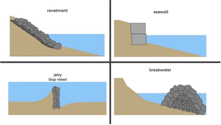
Breakwater A stone or concrete structure built offshore to reduce wave energy at the coast.
Coastal habitat creation Building islands, wetlands, reefs and other features to support coastal ecosystems.
Coastal engineering structure Man-made formation that protects the coast from the forces of waves, water levels, currents, and erosion.
Dredging The excavation of material from a waterway. Dredging is commonly done to make the water deep enough for ships and boats.
Erosion management The analysis and planning of uses of the coast to avoid the impacts of coastal erosion.
Flood control A structures, drainage, or land-use decision designed to reduce the impact of flooding from waves and water levels.
Jetty A stone or concrete structure built perpendicular to the shore to trap sand and hold beach material in place.
Nature-based shoreline engineering Using or mimicking natural features to stabilize the coast. These natural features can include vegetation, beaches, dunes, and reefs.
Revetment Interlocking pieces of stone or concrete on a gentle sloping face built to directly protect the shore from erosion.
Seawall Vertical concrete or stone wall designed to protect the shore from erosion.
This curriculum was prepared by Adam Bechle, Ginny Carlton, and Anne Moser under award number NA21NOS4290005 from the Great Lakes Bay Watershed Education and Training (B-WET) program of the National Oceanic and Atmospheric Administration (NOAA), U.S. Department of Commerce. The statements, findings, conclusions and recommendations are those of the author(s) and do not necessarily reflect the views of NOAA or the U.S. Department of Commerce.