
Lesson 1 – Introduction to Coastal Engineering
LESSON SUMMARY
Middle school students are introduced to the field of coastal engineering and start to become familiar with the engineering design process, a key method coastal engineers use to address problems at our shorelines. Current coastal engineering issues include erosion, loss of habitat, flooding, property damage, threats to human life and wellbeing, and more. The students are also oriented to the location of the field site on the shore of Lake Michigan at North Beach. The geographic positions of the school, Lake Michigan, and Racine Harbor serve as reference points as students build, or enhance, their personal conceptual geographic map of natural and constructed features within the city of Racine.
LESSON CONCEPTS
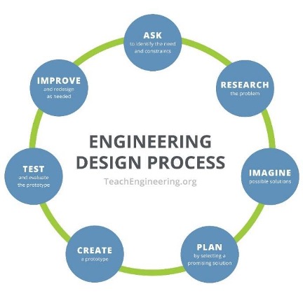
- Science and engineering are related in that they incorporate similar steps. However, the scientific method is a linear process designed to investigate what is, while the engineering design process is iterative and designed to solve an identified problem.
- Maps serve as two-dimensional representations of features on a landscape.
- A map’s key and scale are important to interpreting how a map represents actual features found on a landscape.
LEARNING OBJECTIVES
Students can
- Identify the steps of the engineering design process.
- Explain the similarities and differences between science and engineering.
- Perform tasks foundational to creating a map (e.g., estimate the distance between specified locations and determine the spatial orientation between two locations) by completing a distance and relative position chart.
- Draw a map illustrating the relative positions of the school, Lake Michigan, and a feature of the student’s choice.
- Iteratively use the engineering design process to create a sequence of clay objects with the goal of designing an object that floats.
The link below will download a zipped file containing Microsoft Word documents and Microsoft PowerPoint files. Note that Microsoft Word may not consistently hold formatting. The authors chose to provide Word documents rather than Adobe pdf files so the content can be easily updated for your geographic location.
What is engineering?
- Detailed Version of Lesson 1 – Introduction to Coastal Engineering
- Educator Background Information Introduction to Coastal Engineering – Background
- Slideshow – The Engineering Design Process
- Student Handout – The Engineering Design Process for a Floatable Object
- Slideshow – Racine Harbor Through Time
- Student Handout – My Map of the City of Racine
- Slideshow – Return to Racine Harbor
- Assessment – Science vs. Engineering: Similarities and Differences
- Assessment – Answer Key Science vs. Engineering Answer Key
- Assessment – Lesson 1 Exit Slip
- Assessment – Lesson 1 Exit Slip Answer Key
The link below will open a Google form.
| ACTIVITY | TIME NEEDED |
| Lesson 1: Ideal Apple Pie a la Mode Eating Utensil | 5 minutes |
| Lesson 1: What is Engineering? video | 5 minutes |
| Lesson 1: The Engineering Design Process slideshow | 5 minutes |
| Lesson 1: The Engineering Design Process for a Floatable Object | 15 minutes |
| Lesson 1: Racine Harbor Through Time slideshow | 10 minutes |
| Lesson 1: My Map of the City of Racine | 10 minutes |
| Lesson 1: Return to Racine Harbor slideshow | 5 minutes |
| Lesson 1: Science and Engineering Similarities and Differences | 10 minutes |
| Lesson 1: Exit Slip | 5 minutes |
NEXT GENERATION SCIENCE STANDARDS
Define the criteria and constraints of a design problem with sufficient precision to ensure a successful solution, taking into account relevant scientific principles and potential impacts on people and the natural environment that may limit possible solutions.
Evaluate competing design solutions using a systematic process to determine how well they meet the criteria and constraints of the problem.
Analyze data from tests to determine similarities and differences among several design solutions to identify the best characteristics of each that can be combined into a new solution to better meet the criteria for success.
Develop a model to generate data for iterative testing and modification of a proposed object, tool, or process such that an optimal design can be achieved.
NGSS CROSS-CUTTING CONCEPTS
- Scale, proportion, and quantity. In considering phenomena, it is critical to recognize what is relevant at different measures of size, time, and energy and to recognize how change in scale, proportion, or quantity affect a system’s structure or performance.
- Structure and function. The way in which an object or living thing is shaped and its substructure determine many of its properties and functions.
WISCONSIN MODEL ACADEMIC STANDARDS FOR ENVIRONMENTAL LITERACY & SUSTAINABILITY
ELS.C1.B.m Sense of Place Identify the relationship between parts of natural and cultural systems in connecting communities into regional systems (e.g., watershed areas, political jurisdictions, ethnic communities). Understand the relationships between the environment and geography of a locality and its history, culture, and economy.
ELS.EX5.C.m Examine Cultural System Emphasis Examine how historical and contemporary factors shape a sustainability issue. Evaluate how historical and contemporary natural resource use, practices, and distribution has [sic] affected human geography and analyze the impact on natural systems.
WISCONSIN MODEL ACADEMIC STANDARDS FOR MATHEMATICS
M.7.G.A.1 Draw, construct, and describe geometrical figures and describe the relationships between them Solve problems involving scale drawings of geometric figures, including computing actual lengths and areas from a scale drawing and reproducing a scale drawing at a different scale.
WISCONSIN MODEL ACADEMIC STANDARDS FOR SCIENCE
SCI.ETS1.B.m Developing Possible Solutions A solution needs to be tested and then modified on the basis of the test results in order to improve it. There are systematic processes for evaluating solutions with respect to how well they meet the criteria and constraints of a problem.
SCI.ETS1.C.m Optimizing the Design Solution Although one design may not perform the best across all tests, identifying the characteristics of the design that performed the best in each test can provide useful information for the redesign process. The iterative process of testing the most promising solutions and modifying what is proposed on the basis of the test results leads to greater refinement and ultimately to an optimal solution.
MS-ETS1-2 Engineering Design Evaluate competing design solutions using a systematic process to determine how well they meet the criteria and constraints of the problem.
SCI.ETS3.B.m Science and Engineering are Unique Ways of Thinking with Different Purposes Science asks questions to understand the natural world and assumes that objects and events in natural systems occur in consistent patterns that are understandable through measurement and observation. Science carefully considers and evaluates anomalies in data and evidence. Engineering seeks solutions to human problems, including issues that arise due to human interaction with the environment. It uses some of the same practices as science and often applies scientific principles to solutions.
SCI.ETS3.C.m Science and Engineering Use Multiple Approaches to Create New Knowledge and Solve Problems Engineers develop solutions using multiple approaches and evaluate their solutions against criteria such as cost, safety, time, and performance. This evaluation often involves trade-offs between constraints to find the optimal solution.
SCI.SEP1.A.m Asking Questions Ask questions to clarify or refine a model, an explanation, or an engineering problem.
SCI.SEP4.m Defining a Problem Analyze data to define an optimal operational range for a proposed object, tool, process, or system that best meets criteria for success.
SCI.SEP6.B.m Designing Solutions Apply scientific ideas or principles to design, construct, and test a design of an object, tool, process, or system. Undertake a design project, engaging in the design cycle, to construct and implement a solution that meets specific design criteria and constraints. Optimize performance of a design by prioritizing criteria, making trade-offs, testing, revising, and retesting.
WISCONSIN MODEL ACADEMIC STANDARDS FOR SOCIAL STUDIES
SS.Geog1.a.m Tools of Geography Use paper and digital maps to ask and answer geographic questions.
SS.Geog 1.c.m Mental Mapping and Maps from Memory Construct a mental map of regions.
Great Lakes Literacy Principles
- Principle 6. The Great Lakes and humans in their watersheds are inextricably interconnected.
- 6C: The Great Lakes are affected directly by the decisions and actions of people throughout its watershed which includes parts of the states of Illinois, Indiana, Michigan, Minnesota, Ohio, Pennsylvania, New York, and Wisconsin, the Canadian provinces of Ontario and Quebec, and tribal lands.
- Principle 8B. The Great Lakes are socially, economically and environmentally significant to the region, the nation and the planet.
- 8B: The waters of the Great Lakes have been significant to historical settlement and development. The lakes’ names and the names of many cities, counties and landmarks along their shores have Native American or immigrant origins. This freshwater resource will continue to play a role in future habitation of the area.
(Source: Ohio Sea Grant. (2013). Great Lakes Literacy: Essential Principles and Fundamental Concepts for Great Lakes Learning. OHSU-B-090. National Science Foundation, National Oceanic and Atmospheric Administration, Sea Grant Great Lakes Network, Centers for Ocean Sciences Education Excellence (COSEE))
Complete list of Great Lakes Literacy Principles available at: www.cgll.org
Key Vocabulary
Constructed As an adjective refers to any sort of material forming or earth-moving to make something. For example, constructed dune and constructed wetland are common terms. The word can also be a verb.
Engineering Is a systematic and often iterative approach to designing objects, processes, and systems to meet human needs and wants.
Human-made Pertains to things that result from human actions but are not actually fully formed by humans. For example, “human-made lake” is a term people use rather than “constructed lake” since you don’t usually construct the lake, you construct a dam and then the lake is formed behind it.
Iterative Refers to repetition of the steps as many times as needed, ideally making improvements each time.
Optimize Is to improve a solution based on the results of simple tests including failure to meet predetermined criteria.
Technology Is any modification of the natural world made to fulfill human needs or desires.
This curriculum was prepared by Adam Bechle, Ginny Carlton, and Anne Moser under award number NA21NOS4290005 from the Great Lakes Bay Watershed Education and Training (B-WET) program of the National Oceanic and Atmospheric Administration (NOAA), U.S. Department of Commerce. The statements, findings, conclusions and recommendations are those of the author(s) and do not necessarily reflect the views of NOAA or the U.S. Department of Commerce.