
Lake levels
The first of the following two graphics shows average annual lake levels since 1860; the year in which systematic records were first kept. The second graphic shows the vertical range of water levels on Superior.
Sources of Information
For a comparison with present, or recent, lake levels, visit Forecast Lake Levels. At this site, select Weekly Great Lakes water levels forecast or the Monthly Bulletin of lake levels for the Great Lakes.
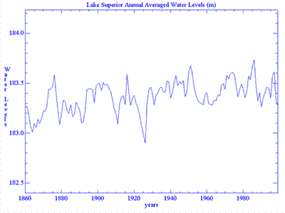
Water levels in the graphic shown above are given in meters above International Great Lakes Datum, 1985. Credit: Gene Clark
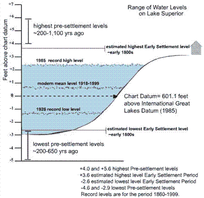
Water levels on the graphic shown above are given in feet above and below Chart Datum, or Low Water Datum, of 601.1 feet, International Great Lakes Datum, 1985. Credit: Gene Clark
The water levels of Lake Michigan and Huron rise and fall together. These lakes are connected through the Straits of Mackinac. The first graphic shows the historic sequence of average annual water levels beginning in 1860; the first year of systematic water level recording. The vertical range of water levels in Lake Michigan (and in Lake Huron) are given in the graphic below.
Sources of Information
For a comparison with present, or recent, lake levels, visit Forecast Lake Levels. At this site, select Weekly Great Lakes water levels forecast or the Monthly Bulletin of lake levels for the Great Lakes.
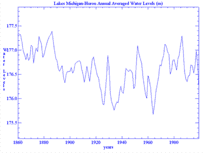
The water levels in the graphic above are given in meters above the International Great Lakes Datum, 1985.
Credit: NOAA Great Lakes Environmental Research Lab, Ann Arbor, Michigan
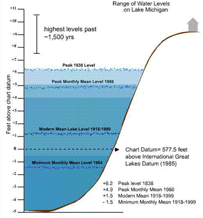
The range of water levels in Lakes Michigan and Huron in the graphic above are given in feet relative to Chart Datum, or Low Water Datum (LWD) of 577.8 feet, International Great Lakes Datum, 1985 (IGLD 1985). This LWD is 176.0 meters above IGLD 1985.
Credit: Gene Clark
The water levels in the graphic shown below are average annual water levels recorded since 1860; the first year of systematic data gathering. These levels are given in meters above International Great Lakes Datum, 1985 (IGLD 1985).
Sources of Information
For a comparison with present, or recent, lake levels, visit Forecast Lake Levels. At this site, select Weekly Great Lakes water levels forecast or the Monthly Bulletin of lake levels for the Great Lakes
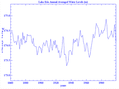
Datum, or Low Water Datum (LWD) on Lake Erie is 173.5 meters above IGLD 1985.
Credit: NOAA Great Lakes Environmental Research Laboratory, Ann Arbor, Michigan
The following graphic shows the range of average annual water levels on Lake Ontario since 1860; the year that systematic water level recording began.
Sources of Information
For a comparison with present, or recent, lake levels, visit Forecast Lake Levels. At this site, select Weekly Great Lakes water levels forecast or the Monthly Bulletin of lake levels for the Great Lakes.
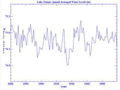
The levels in the above graphic are given in meters above international Great Lakes Datum, 1985 (IGLD 1985). The Low Water Datum (LWD), or Chart Datum for the lake is 74.2 meters above IGLD 1985.
Credit: NOAA Great Lakes Environmental Research Lab, Ann Arbor, Michigan